|
by Dr Chrysoula Papacharalampou A visit to the Bath Record Office Archives and Local Stories (or Bath Record Office for short) of the Bath & East Somerset (B&NES) Council will reveal a hidden treasure of documentary evidence relating to the evolution of local flood policy (Figure below). This includes notes from the Council’s (Major’s) meetings, articles in the local press, correspondence between local stakeholders, industrial actors and citizens, extensive inventories/catalogues of on-site inspections and compensations bills. 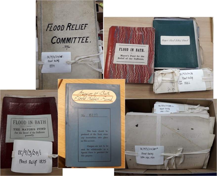 Figure. Photos from archive search in the Bath Record Office The available evidence suggests that major historical flood events have been catalysts for policy change at the city level. A range of local policies, mainly focussing on a post-event response, were initiated and implemented by local stakeholders or ‘policy entrepreneurs’ (i.e. advocates for proposals) following the major flood events. This local and post-event policy development and implementation was due to the absence of government authorities for flood management in the United Kingdom until 1930, when the Land Drainage Act was enforced. The policy entrepreneurs for the City of Bath included the Mayors of Bath, members of the local Council, engineers and local industry. The severity of each individual event in terms of its impact on the local communities appears to have shaped the action planning and decision-making. Public opinion and concern regarding flood events and their impact seem to have influenced the implementation of plans requiring local investment. The policy actions relate to three main areas: (1) citizen’s relief, (2) infrastructure development, and (3) institutional change. A number of initiatives to alleviate the distressed local population were launched mostly as an immediate response to major flood events. Flood management in the 19th centuryRelief funds and actions of social and corporate responsibility are extensively documented after the flood events of 1882 and 1894. The Mayor’s Relief Fund following the 1882 flood, served to the provision of food supply, compensation for losses of assets and partial restoration of households. Evidence of the distribution of these relief funds can be retrieved in the Bath Record Office, inclusive of letters to the Flood Relief Committee (established as a response to the 1823 flood) requesting refunds for cattle which drowned during the event. Local industry showed their corporate responsibility by offering accommodation and tons of coal, whilst the police force made a public appeal for food and clothing supplies. The floods of 1894 (13th and 15th November, two distinct floods three-days apart) reported as ‘most serious and calamitous’ on record, had socio-economic impacts on the population: properties, business and trade stock were inundated, washed away or destroyed. These events triggered social response and raised actions of high social responsibility from citizens, local tradesmen and the policy force. The local authorities formulated an emergency committee aimed at relieving the distress. Similarly to past policies, actions of immediate relief included distribution of food (i.e. bread, cheese, coffee) distributed in baskets (kind offer of local bakeries and tradespeople/shops), offer of meals in public spaces, provision for accommodation and coal tickets, as the city experienced a complete gas and lighting cut-off. Two separate relief funds were raised (i.e. St James Relief Fund, Public Relief Fund), both aimed at alleviating the ones affected. Next to the measures for alleviating stress, post-flood policies relate to the safety of the local society at large, in the more recent years: after the 1960 flood, a Major Disaster Plan (outlining managing options for severe events) was assembled and new jobs were created within the local police force. The historical records indicate flood mitigation in the City of Bath has mainly been focussed on engineering/infrastructure solutions. Reports for infrastructure projects were commissioned at multiple points in history, mainly triggered from a severe flood event, but implemented only when economic incentives and availability of public funds allowed. These reports outlined a series of preventive measures, including the replacement of bridges and the widening of the riverbanks. Available records of the reports show converging expert opinions on the mitigation solutions. For example, the 1823 flood resulted in the commission of an engineering report to the city engineer Thomas Telford in 1824, which recommended the removal of obstruction across the river channel and the replacement of the Old Bridge by a single arch bridge. The total estimated costs for the solutions proposed (£50,000) did not lead to its fruition. Similarly, after the flood event in November 1875, further engineering recommendations were made in a report published by Alferd Mitchell, who suggested the use of weirs across the length of River Avon. The recommendations were aimed to increase the discharge capacity of the water system, but no further actions were taken at the time. In 1892, a decade after the ‘surprising’ 1882 devastating flood event, a new report outlined a series of infrastructure measures for future flood defence. The estimated cost (£100,000) of the flood defence measures was deemed immoderate to proceed with the implementation of the plan. The catastrophic events of 1894 resulted in the commission of yet another engineering report commissioned (1896) to G. Remington. This report outlined a radical suggestion: diversion of part of the floodwater of the River Avon through a tunnel of 86 sq. ft. (approx. 8m2) cross-sectional area. The estimated cost of the plan reached £69,300 and public concern regarding the impact of floods had grown, supporting a proactive approach to the mitigation of flooding. Yet, no plans were taken forward for implementation. Flood management in the 20th centuryIn the beginning of the 20th century, a series of flood incidents were reported in Bath (1903, 1925, 1932, 1935, and 1936). There is limited documentary evidence on the impact or alleviation policies following the events. Nonetheless, these incidents coincide with the enactment of the Land Drainage Act (1930). This was aimed to launch a new set of administrative structures to effectively manage the drainage of low-lying land at a national level. As a result of its implementation at a local level, the Bristol Catchment Board was established as the first government authority managing the River Avon Catchment. Shortly after it was founded, the Bristol Catchment Board adopted a proactive approach to flood management. In addition, the launch of the Inland Water Survey in 1935 marked the beginning of data-driven flood management, with several gauging stations being installed across the country. In Bath, the gauging station of St James (central Bath) started its operation in 1939, as proven by the available records of daily flow. ConclusionConsidering the flood policy development in the City of Bath, a pattern emerges: throughout the 19th century, and despite the severity, impact and frequent of flood events, no coherent or preventive policy was implemented due to a lack of funds and sense of urgency among the citizens. The emergence of a government authority responsible for mitigating flood impacts, coupled with the convergence of public opinion and political priorities enabled the development and implementation of prominent and potent policy agenda. Sources
A record of the Great Flood in Bath and the surrounding district (1882). Special Issue of The Bath Herald. Bath: William Lewis and Son. A record of the Great Flood in Bath and the surrounding district (1894). Special Issue of The Bath Herald. Bath: William Lewis and Son. Buchanan, R.A. (1988). The Floods of Bath. In: B.B. Buchanan (Ed.), Bath History Volume VII 1998. Bath: Millstream Books, pp.167-185. Coode, Son and Matthews (1892). Bath Floods Prevention Report. Bath. Gallois, R.W.(2006). The Geology of the Hot Spring at Bath Spa, Somerset. Geoscience in south-west England, 11, pp. 168-173. Greenhalgh, F. (1974). Bath Flood Protection Scheme. Bath: Wessex Water Authority. Kingdon, J. W.(1984). Agendas, Alternatives and Public Policies, pp. 13-39. (Boston, MA: Little, Brown). Land Drainage Act (1930). First Schedule Minor Amendments, part I. Available at: www.legislation.gov.uk Mainwaring, R. (1838). Annals of Bath from the year 1800 to the Passing of the New Municipal Act. Warner, R. (1801). The History of Bath. Wood, J. (1742). A Description of Bath. 3rd edition, Bath, 1765; reprinted Bath, 1969.
32 Comments
By Ioanna Stamataki and Thomas R. Kjeldsen
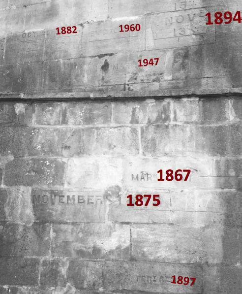
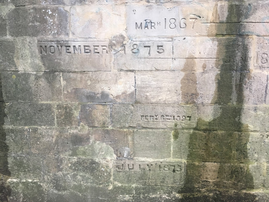
In the last couple of months, we have continued to work on our 1D hydraulic model of City of Bath as it was predating the current Bath Flood Defence Scheme. As previously mentioned, developing a hydraulic model representing historical conditions is not an easy task and requires different aspects to be carefully considered. The aim of the research was to reconstruct historical floods for which a flood mark existed at Halfpenny Bridge – January 1866, March 1867, July 1875, November 1875, October 1882, November 1888, March 1889, 13th November 1894, 15th November 1894, February 1897, December 1900, February 1900, June 1903, January 1925, March 1947 and December 1960. The reconstruction will ultimately result in a more accurate assessment of the peak flow of the events, which is potentially useful to understand the contemporary flood risk facing the city of Bath.
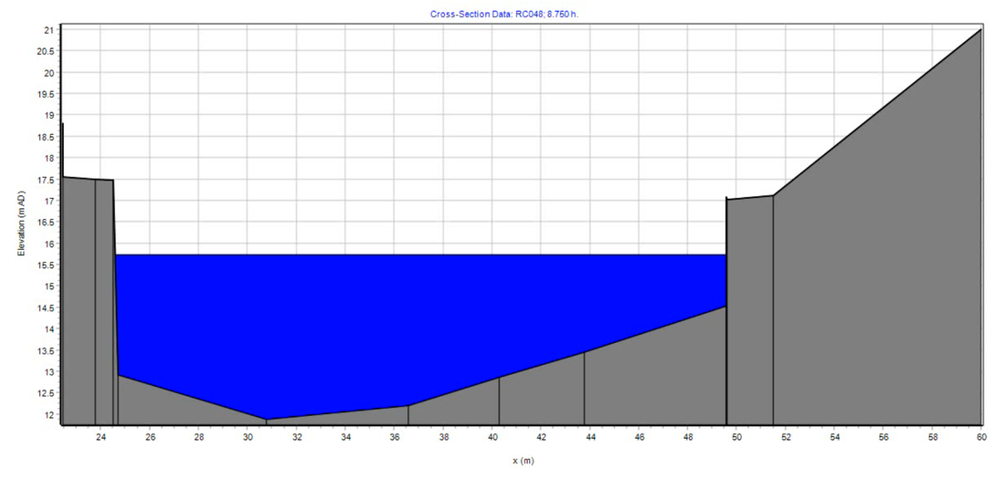
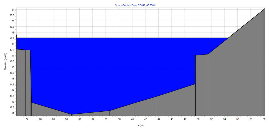
Having separated the river channel into cross sections from section CS232 in Bathampton down to section CS155 located by Lower Twerton Weir (for more info refer to our previous blog post Hydraulic modelling of Bath's historical floods pre-Bath Flood Defence Scheme: Part I) it became obvious that during all the historical flood events the floodplains around the river were inundated (which was also evident from historical pictures), an effect that was not represented accurately in our model. To further understand the hydraulic balance between the river and the floodplains of the catchment area, we started looking closer at historical pictures from the floods in Bath, mainly from the 1960, 1882 and 1894 floods. Using the Bath in Time online archive numerous photos of Bath during flood events were identified, which initiated the creation of our own interactive historical flood map containing historical photos from Bath in Time overlaid with the Environment Agency’s historic flood map GIS layer showing the maximum extent of individual Recorded Flood Outlines based on records from 1946. At this stage, the objective was not to investigate whether individual street or properties were flooded at the time of the events, but to understand the size of the different floodplains of the city. This allowed us to extend our cross sections to incorporate the effect of the floodplains into the hydraulic model. Figure 1 shows River Avon Cross Section CS200 located about 150 meters downstream from North Parade Bridge. The continuous black line shows the river cross section obtained from an archived engineering drawing and the dashed black line shows the extended floodplains (calculated using the interactive map) towards the Dolomeads.
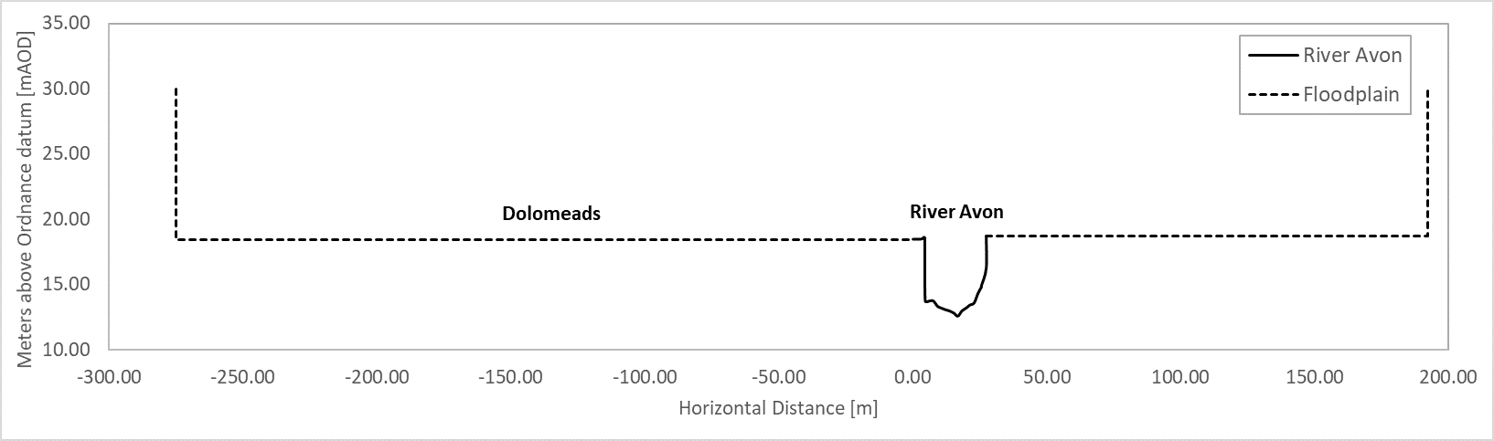
Figure 1. River Avon Cross Section CS200 and extended floodplains towards the Bath Cricket Ground and Dolomeads
The final result of our interactive map is shown in Fig.2 below. The legend on the left is separated in three categories:
Figure 2. Interactive map with historical flood photos and flood extents
We hope you enjoy it, please feel free to navigate it and don’t forget to leave us your comments & thoughts!
Sources
Photos: Bath in Time, 2019 [Online]. Available from: https://www.bathintime.co.uk/ Historic Flood Map: Environment Agency. (2020). Historic Flood Map. Available from: https://data.gov.uk/dataset/76292bec-7d8b-43e8-9c98-02734fd89c81/historic-flood-map By Ioanna Stamataki and Thomas R. Kjeldsen Twerton, also known as Twiverton on Avon, is a suburb of the city of Bath, located to the west of the city, and home to Twerton Weirs built as part of the Bath Flood Protection Scheme. As discussed in previous blog posts, the City of Bath has a long history of flooding going back centuries, and after the important flood of 1960, the Bath Flood Defence Scheme (1964-1974) was initiated and consisted of ten phases aiming to incorporate different improvements to the river hydraulics. Phases IV & V of the scheme were the removal of the two weirs at Twerton and replacement by a twin automatic sluice barrage. Twerton is considered a Saxon settlement on the River Avon but there is evidence that the village existed since the Roman times (THE BATH Magazine, 2020). It was considered outside the borders of the city until 1911 but it was known for its mills milling corn and later cloth. This is translated into its name “Twerton” which is derived from an Anglo-Saxon word meaning “Two Weirs” and illustrating the suburb’s riverside location (THE BATH Magazine, 2020). 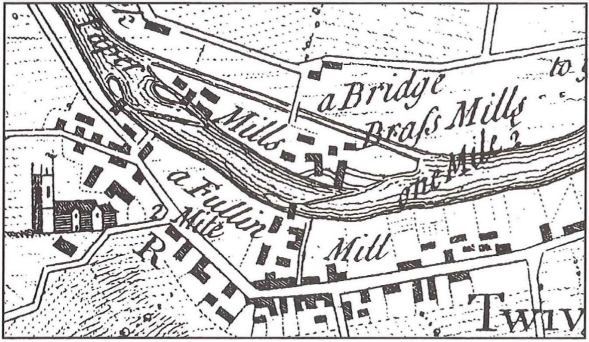 Figure 1. Map of Twerton mill sites in the eighteenth century (Von Behr, 1996). At the beginning of the Industrial Revolution, the West of England was known for its wool textile manufacturing. Twerton had five mills located around the two weirs that were being leased (Figure 1). Twerton’s manufacturing was therefore indistinguishably connected with the River Avon and the weirs. The first mention of a weir appears as early as 945 AD (Von Behr, 1996). Joan Day (1987) writes “Two adjacent weirs (Figures 1,2) both served ancient fulling-mill sites on either bank of the Avon which here divides Weston and Twerton. Other diverse industries later occupied the sites, but the complex survived into this century mainly as large cloth-mill premises”. In the middle of the sixteenth century the Bath cloth industry collapsed, and by the seventeenth century the downstream mills were reverted to grist milling¹ (Von Behr, 1996). 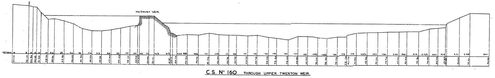 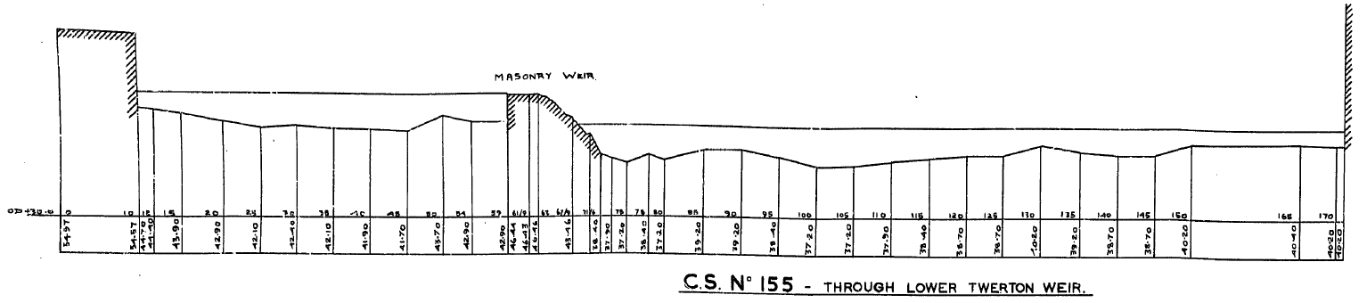 Figure 2. Cross sections of upstream (top) and downstream (bottom) Twerton Weirs In 1727, the Avon Navigation was completed connecting Bath to Bristol for navigation and during this time the Weston cut was created; a man-made channel on the north bank of River Avon created to allow boats to go through Weston lock. Between the river and Weston cut, an island was created, Dutch Island, which took its name from one of the brass mill owners (Allsop, 1989; Von Behr, 1996). The Weston cut left the existing Weston mills somewhat isolated on Dutch Island with a single footbridge access erected in 1728 (Day, 1987). 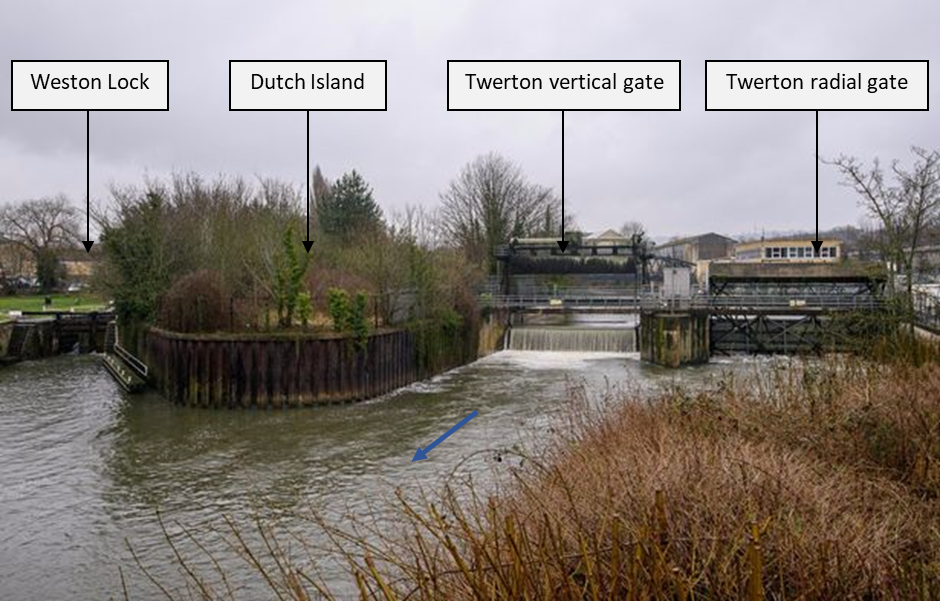 Figure 3. Photo of twin gate system at Twerton looking upstream. The photo shows the Weston Lock, Dutch Island, Twerton vertical gate and the Twerton radial gate. The blue arrow represents the direction of the flow (Somerset Live, 2018). Figure 4. Map showing the location of the twin gate system at Twerton Phases IV & V of the Bath Flood Defence Scheme were completed in June 1968 (Greenhalgh, 1974) and the two weirs (Figure 2) that stood at Twerton were replaced by a twin gate system (Figure 3 and Figure 4), a vertical and a radial gate spanning the length of the river (BATHNES, 2016a). Their purpose is to maintain the water level in the city centre within a viable range to: (i) facilitate navigation, and (ii) protect the historical World Heritage building foundations. Operation of the sluice gate is automated, and it opens/closes as required to maintain the required water level (BATHNES, 2016a). The usual water level range within the Twerton Gates Monitoring Station operates the gates is between 15.42 and 15.54 mAOD (River Levels, 2020). In October 2019, the Twerton radial gate got stuck open due to a fault causing the water level to drop by 0.8 m overnight and a further 0.1 m in the morning. The gate was fixed into its closed position and the levels were controlled by the remaining Twerton gate (Bath Echo, 2019). Figure 5 below shows the data available from the River Levels database showing the minimum daily water level recorded between June 2019 and June 2020. The sudden drop in the data represents the October incident and shows the extraordinary water level drop in October. 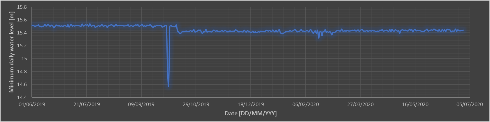 Figure 5. Timeseries of minimum daily water level between June 2019 and June 2020 (Data from River Levels, 2020 The Bath & North East Somerset Council in their 2016 “Bath River Options Appraisal Report” have been discussing the possibility to replace the Twerton gates. It is recognised that these structures play an indispensable role in the flood risk protection of the city of Bath and are looking into many different options taking into account efficiency, economic benefits, environmental enhancements and climate change. The short-listed options that were decided in this report were: (i) do minimum, (ii) replace both gates and (iii) replace both gates with a variable height weir (BATHNES, 2016b). ¹ A mill, especially one equipped with large grinding stones for grinding grain (Collins English dictionary, 1994). Sources
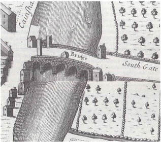
Allsop, N., 1989. The Kennet & Avon Canal. 2nd ed. Millstream Books. Bath Echo, 2019. Twerton sluice gate fault sees River Avon water levels drop across Bath [Online]. Available from: https://www.bathecho.co.uk/news/community/twerton-sluice-gate-fault-sees-river-avon-water-levels-drop-across-bath-86584/ [Accessed 25 June]. BATHNES, 2016a. Flood risk in Bath. Available from: https://www.bathnes.gov.uk/sites/default/files/siteimages/Environment/flood_risk_in_bath_feb_2016.pdf BATHNES, 2016b. Bath River Avon Options Appraisal Phase 1b and 2. Available from: https://www.bathnes.gov.uk/sites/default/files/river_avon_options_appraisal_report_phase_1b2_final_v3_20.09.16.pdf Collins English dictionary. (1994). Glasgow: HarperCollins Publishers. Day, J., 1987. A guide to the industrial heritage of Avon and its borders. Association for Industrial Archaeology. River Levels, 2020. Twerton Gate Monitoring Station [Online]. Available from: https://riverlevels.uk/somerset-twerton-gate#.XwbyhSgzY2xTwerton%20Gate%20Monitoring%20Station [Accessed 25 June]. Somerset Live, 2018. Hundreds of Twerton homes to benefit from multi-million-pound flood defence investment [Online]. Available from: https://www.somersetlive.co.uk/news/hundreds-twerton-homes-benefit-multi-1392912 [Accessed 25 June]. THE BATH Magazine. 2020. History: Indispensable Twerton. [ONLINE] Available at: https://thebathmagazine.co.uk/history-indispensable-twerton/ [Accessed 30 June 2020]. Von Behr, N., 1996. The cloth industry of Twerton from the 1780s to the 1820s Bath History Volume VI. Available at: http://historyofbath.org/images/BathHistory/Vol%2006%20-%2005.%20von%20Behr%20-%20The%20Cloth%20Industry%20of%20Twerton%20from%20the%201780s%20to%20the%201820s.pdf By Ioanna Stamataki and Thomas R. Kjeldsen Bridges are civil engineering structures that often have important historical significance. The City of Bath was built around the banks of the River Avon and the natural springs and the economic prosperity these brought depended upon the construction of important transport routes. Permanent crossing points and bridges therefore played an important role from Roman times. In the last two centuries bridges became an important part of the city, not only for their practicality but also their elegance (Buchanan, 1990). Figure 1. Location of Churchill Bridge in Bath, UK The present-day Churchill Bridge crossing the River Avon in Bath’s city centre (Fig. 2, right) is a single span bridge and represents one of the main routes into the city connecting the centre of Bath to its southern suburbs (see Fig. 1 map). But Churchill Bridge was not always a single span bridge. Initially – where the current Churchill Bridge now stands – a five-arch stone bridge was constructed in 1754 called Old Bridge (Fig. 2, left) only to be replaced in 1965 by the current Churchill Bridge as part of the Bath Flood Protection Scheme. As discussed in previous blog posts, the City of Bath has a long history of flooding going back centuries, and after the important flood of 1960, the Bath Flood Defence Scheme (1964-1974) was initiated and consisted of ten phases aiming to incorporate different improvements to the river hydraulics. Phase I of the scheme was the replacement of Old Bridge with two single span bridges for road (Churchill Bridge) and pedestrian traffic. 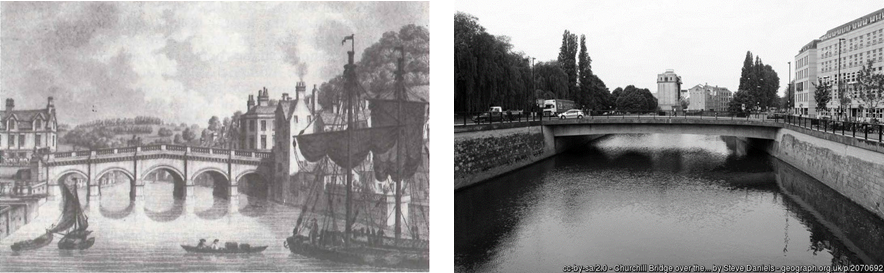 Figure 2. River Avon, Old Bridge (left) and Churchill Bridge (right) However, the story of Churchill Bridge starts much earlier during Roman times with the Roman Bridge located at the same site, an area considered outside the borders of the city until 1590. There is evidence that a more permanent bridge was located there in 1273 (Buchanan, 1990) and it is believed that it was built before 1220 (Somerset HER, 1984), and that there probably was a wooden bridge there even earlier (Buchanan, 1990). At the time it was called St. Lawrence's Bridge (Somerset HER, 1984) and it was a bridge with houses and a chapel dedicated to St Lawrence which survived until 1749 (Buchanan, 1990; Davis, 1857). It is believed that St. Lawrence's Bridge was destroyed during the English Civil War and during 1754, Richard Jones designed Old Bridge which the Bath corporation built on the existing piers of St Lawrence’s Bridge (Ison, 1980).
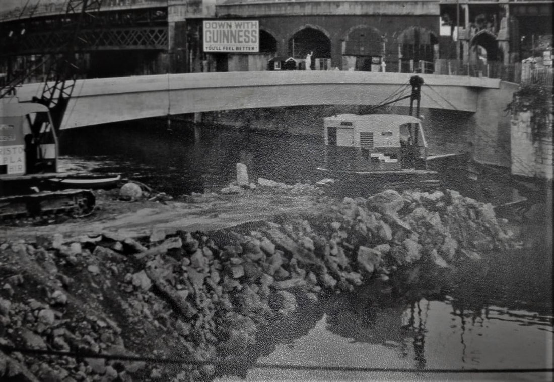
The view of flooded Saint Laurence's Bridge, and later Old Bridge, with water covering the bridge parapets was a familiar image for the 18th and 19th century Bath residents (Buchanan, 1990). The flooding of Bath has been documented by multiple accounts with flood marks on buildings through-out the city (earliest from 1823) as well as documentary evidence in books, newspapers and technical reports. The floods in Bath were regular and over the years created considerable damage to the city’s property but unusually low numbers of casualties (Buchanan, 1990). The five-arch masonry bridge, Old Bridge, was identified very early as being prone to debris blocking and an obstacle to flow (Greenhalgh, 1974; Buchanan 1990). During the floods it was acting as a bottleneck and was retaining upstream the flood water and occasionally (e.g. 1823 flood) its arches were blocked by lots of timber (Buchanan 1990). Despite different attempts to refurbish the bridge, it remained the most important obstruction to the unrestricted flow of the River Avon on its way through Bath’s City centre and consequently it was removed in 1964-1965 and replaced by the current single-span Churchill Bridge, thereby dramatically changing the river hydraulics. 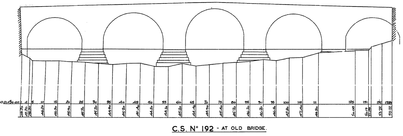 Figure 4. Cross section at Old Bridge taken in 1934 (scanned drawing from the Environment Agency’s Archives, Bridgwater) By creating a simple 1D hydraulic model in the Flood Modeller software, the effect on flood levels of the two different bridges (Old Bridge and Churchill Bridge) was investigated by considering their hydraulic performance during the 1960 flood (Fig. 5). This particular flood was considered a catalyst event for the policy of Bath as due to the city’s development, the economic impact was vast. 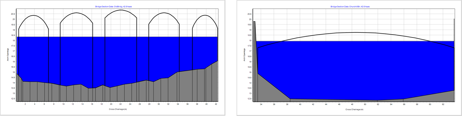 Figure 5. Screenshot of numerical simulation during the 1960 flood event at Old Bridge (left) and Churchill Bridge (right) To investigate the effect of the two bridges, we looked at the time series data of stage (how the water level changed over time) in three locations (Fig. 6):
A way to understand the effect a bridge has in a water stream is to calculate its afflux which is the difference in water level caused on the upstream side of a bridge (the side against the direction of the flow) due to the obstruction. Flood Modeller calculates the afflux on bridges using a method developed by HR Wallingford based experimental data (Brown, 1988). The two graphs on Fig. 6 show the stage time series for Old Bridge (left) and Churchill Bridge (right) during the 1960 flood. What is noticeable is that Old Bridge created a 0.5 metre surge in water level upstream and at the bridge location when compared to the Churchill Bridge because of its geometry restricting flow. 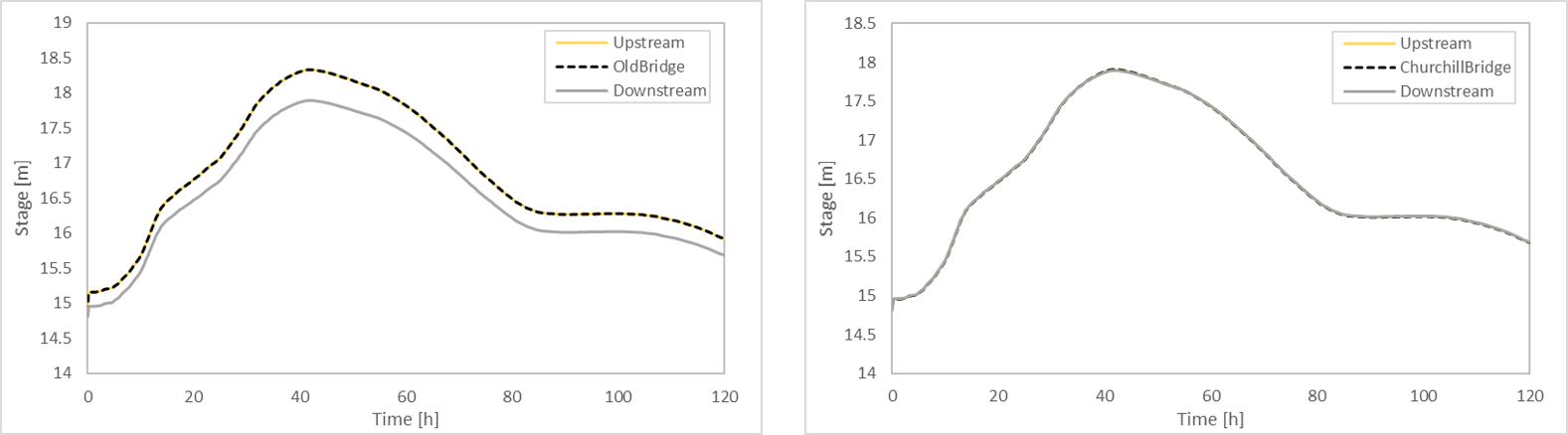 Figure 6. Timeseries of stage during the 1960 flood for Old Bridge (left) and Churchill Bridge (right) Even though the hydraulic behaviour of river systems is complex, especially when hydraulic structures are introduced, Old Bridge proved to have been correctly identified as being prone to debris blocking and an obstacle to the River Avon’s flow. To understand the full effect of the Bath Flood Defence Scheme, requires a complex investigation but as the effect of Old Bridge was very apparent in most historical floods in Bath, understanding the effect of this individual structure was a very important part in our research. Sources
Bird, S. (1986). ‘The Earliest Maps of Bath’ in Bath History, Volume I. Gloucester: pp.128-149. Brown, P. (1988) Afflux at arch bridges. Technical Report. HR Wallingford. Buchanan, R.A. (1990) 'The Bridges of Bath', in Bath History, Volume III. Gloucester: pp.1-21. Davenport, P., 2002. Medieval Bath Uncovered. Tempus. Davis, C.E. (1857) On the Churches of Bath. Journal of the British Archaeological Association, 13.2, 135 Environment Record [Online]. South West Heritage Trust. Available from: https://www.somersetheritage.org.uk/record/61616 [Accessed 25 May]. Greenhalgh, F. (1974) Bath Flood Protection Scheme. Wessex Water Authority Ison, W. The Georgian Buildings of Bath. (1980), 46-48. Somerset Historic Environment Record HER, 1984. St. Lawrence's Bridge, E of Churchill Bridge, Bath: Bath & NE Somerset Historic Wood, John, 1765 (2edn), A Description of Bath (London) p. 325, 326 by Ioanna Stamataki and Thomas R. Kjeldsen In the last couple of months, we have been working on a 1D hydraulic model of the stretch of the Bristol Avon flowing through the City of Bath as it was predating the current Bath Flood Defence Scheme. Hydraulic models are a numerical representation of a river and are used as an investigation tool to understand a system’s hydraulic behaviour. They can be useful for flood prediction, planning, catchment management, mitigation strategies, future infrastructure works and in this case for reconstruction of historical flood events. 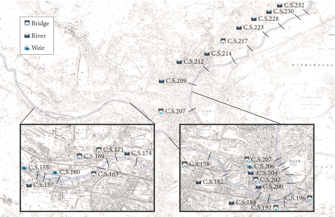 Figure: Map of the city of Bath highlighting the River Avon and the position of the river cross sections, bridges and weirs modelled in the hydraulic model Building a historical model is not an easy task and requires different aspects to be carefully considered. First, the river channel is separated into cross sections that represent the geometry of specific locations and are either simple river cross sections, bridges or weirs. The longitudinal distance between the cross sections also needs to be specified. The schematic below shows a simplified setup with an input hydrograph (the flow rate in the river over time) at the upstream end of the river, an initial river cross section, a bridge and another river cross section.  Figure: Schematic showing a simplified setup with an input hydrograph, an initial river cross section, a bridge and another river cross section. The first stage of the modelling process was therefore to create the numerical model for the River Avon and to achieve this we needed to obtain historical data of the river geometry and infrastructure at the time of the historical floods. The development of the model required river cross section data for the river Avon, historical maps, historical water levels and details of the bridges and weirs along the river’s path. We found on DIGIMAP a historic map showing details of the river geometry pre-Bath Flood Defence Scheme and decided that the study would create a model including approximately 8 kilometres of the River Avon from Bathampton Weir (cross section C.S.232) and down to the Twerton weir (C.S. 155) downstream of Bath city centre. The 54 river cross sections used for the historical model construction were found after extensive search in the Environment Agency’s Archives in the Bridgwater office among another 1112 scanned drawings relevant to the Bath Flood Protection Scheme. They were part of a longer survey of a total of 233 recorded locations which were measured in 1934 and replotted later to Newlyn Datums (the ordnance datum used as the basis for deriving altitudes on maps). An example of a cross section is shown below containing details of Old Bridge, which used to cross the river behind Bath’s train station until it was replaced with the current-day Churchill Bridge during Phase I of the Bath Flood Defence Scheme. 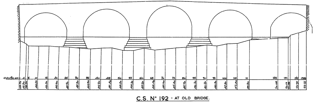 Figure: Cross section containing details of Old Bridge (replaced with current-day Churchill Bridge) To create a realistic flood model, we also needed reliable flood data and information. Flood hydrographs are graphs that show how a catchment responds to a rainfall event by plotting the flow rate over time for the duration of the flood. In numerical models, we introduce a hydrograph at the upstream boundary, in this case Bathampton, and let the water propagate through the river model. To start our model reconstruction, we were lucky enough to have found the water levels recorded during the 1960 flood on microfilm in the archives of the UK Centre of Ecology and Hydrology in Wallingford. The figure below shows the scanned hydrograph of the 1960 flood in Bath measured at St James’ Bridge which is located 3.3 km downstream from Bathampton and 200 metres upstream of the Pulteney Weir. 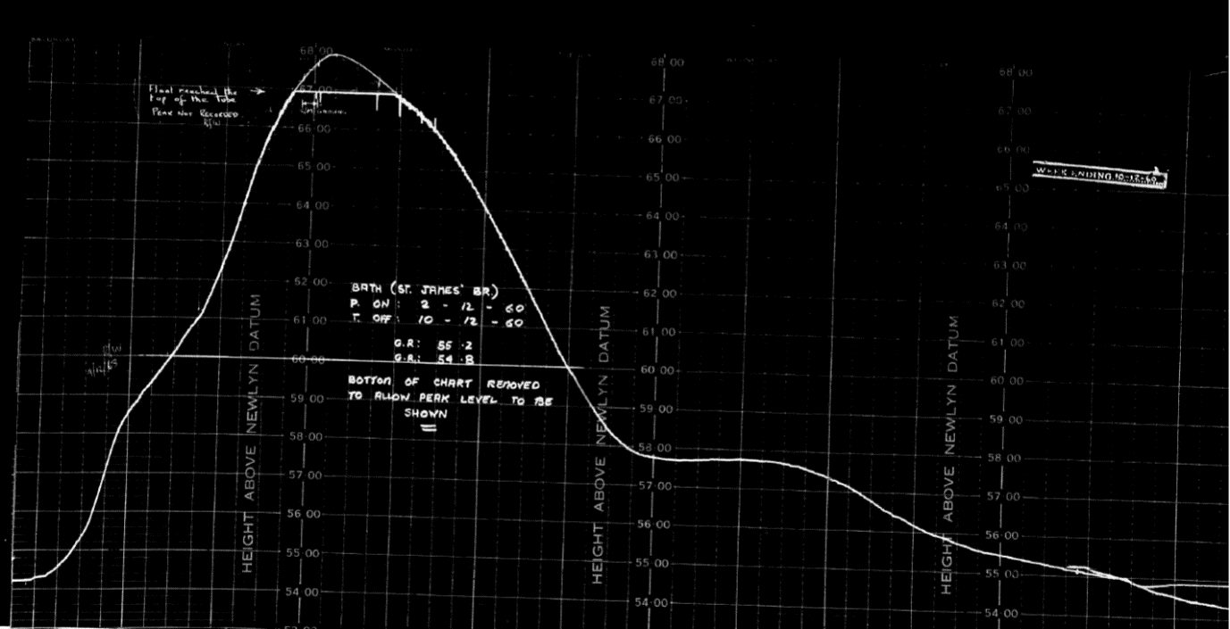 Figure: Scanned hydrograph of the 1960 flood in Bath measured at St James’ Bridge Using the software Flood Modeller a 1D model of the River Avon was constructed by combining the data representing the river geometry and the hydrology. The model provides an accurate representation of the river’s physical characteristics and hydraulic structures (bridges, weirs) between Bathampton and the Twerton weirs as it appeared before the implementation of the Bath Flood Defence Scheme. For the model construction, we started by digitising the 1960 hydrograph and all river cross sections. We started with the microfilm hydrograph for the 1960 flood which was manually scanned, digitised and translated from water depth to flow rate using a rating curve (a graph showing the relationship between flow rate and water depth at a given point of a river). Following that all cross sections were also digitised manually from the PDF files and the units were converted from “feet” to “meters”. Starting at the upstream end of the river in Bathampton, we started then to build the model. The digitised 1960 flood event was defined as the inflow hydrograph at the top of the numerical model. Next, the different river cross sections were added and the distance between them and the channel roughness specified. Finally, all hydraulic structures were implemented (bridges, weirs) using the geometric data from the cross sections. The slideshow below shows the inflow 1960 hydrograph, two river cross sections and the representation of Old Bridge in Flood Modeller. There are different outputs that can be extracted from the numerical model. Important and useful results in our research are the velocity, water depth or flow rate over time (hydrograph) at a specific location. It is also possible to visualise the results (as shown in the images below) and examine the water depth evolution at a specific cross section (in this case at Halfpenny Bridge) over time during the 1960 flood.
Figure: Visualisation of results at Halfpenny Bridge during the 1960 flood event The next stage of the research is to simulate some of the historical floods (e.g. 1960, 1894, 1882) and using the historical water marks at Halfpenny Bridge produce new modelled peak flows and compare them with the previously estimated flows. This stage will be described in the second part of this blog post so stay tuned in the next weeks. Acknowledgements
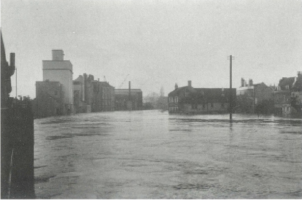
The authors are grateful to the Environment Agency staff in Bridgwater and the Centre of Ecology and Hydrology for their help and assistance. We would also like to show our gratitude to Jacobs for providing a Flood Modeller license allowing us to undertake this research. by Ioanna Stamataki & Thomas R. Kjeldsen Bath has always had a mixed relationship with the river Avon. Only in recent years have new developments such as Bath Quays Waterside started promoting river living as desirable and reconnecting Bath to its river, whereas all historical buildings located riverside are facing away from the river; resembling the city turning its back on flooding and poor water quality. The history of efforts to combating the scourge of flooding in the city of Bath has been documented by illustrious accounts by, for example, Buchanan (1998) and Greenhalgh (1974). Buchanan (1998) traced evidence of flooding back to Roman times, but modern accounts starts in the 19th century. Following flooding in 1823 (flood marks can be found in Grove Street) a Flood Relief Committee was formed, who commissioned Thomas Telford (a famous engineer of the time) to propose a solution. His scheme was costed at about £47,000 (£5,311,000 in today’s money) and included removal of obstacles such as the five arch Old Bridge (present day Churchill Bridge) and re-alignment of channel section to increase flow capacity. However, at the time the scheme was considered too expensive and never materialised. Instead, people and businesses impacted by flooding was compensated by the Major’s Relieve fund. 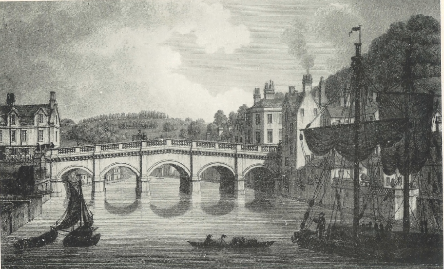 Figure: The Old Bridge from a plate by W. Watts, 1819 (Smith, 1948 Following a record-breaking flood event in October 1882 (flood mark can be seen under Halfpenny Bridge), the Bath Cooperation commissioned another report into flood defence options, which resulted in a scheme designed by Messrs Coode, Son and Matthews proposing a series of infrastructure measures which included: deepening of the river, enhancement of existing weirs, replacement of Old Bridge and enhancement of existing bridges with steel sheet piles. His scheme was estimated at about £100,000 (£12,058,301 in today’s money). A more imaginative scheme was proposed after the two distinct floods of 13th and 15th November 1894 by Mr Remmington, a London -based engineer, who in 1896 proposed a by-pass channel from Limpley Stoke Valley to below Twerton. Neither schemes were ever carried through to construction. Extensive flooding followed in 1947 and in 1953 the then chief engineer Frank Greenhalgh (Chief Engineer) initiated work on what would eventually become the present-day Bath flood protection scheme. A scheme proposed some year’s earlier by Mr Greenhalgh’s predecessor, Mr Mercer, similar to the 1882 scheme, had been abandoned at the outbreak of WW2. Four options were initially considered for the flood defence scheme
The first option was considered uneconomical, and no suitable location with sufficient space could be identified near Bath. The third option was presumably unsightly as well as concerns about seepage and lack of drainage facilities. As a result, the fourth option was chosen, noticing its resemblance to the original scheme proposed in 1823 by Thomas Telford. The implementation of the Bath Flood Protection Scheme consisted of ten phases summarised below.  Figure: The Bath Flood Protection Scheme
Phase VII: Pulteney Weir remodelled and provided with a new sluice gate, protection of Pulteney Bridge foundations and regrading of channel ceases. Phase VIII: Diversion of Services wherever they occur. Phase IX: One bank to have vertical masonry faced concrete wall and the other bank to be sloping earth with stone toe protection. Phase X: Dredging along length from Twerton to upstream limit. The scheme was designed to defend the city against the worst flood on record which at the time was considered to be the 1882 flood, estimated to have a peak flow of 12,950 cusecs (366.7 m3/s). However, in December 1960 Bath experienced an even larger flood, peaking at an estimated flow rate of 424.4 m3/s (this is estimated as the flood exceeded the capacity of the monitoring system).
Figure: Photographs of the 1960 flood by Rec. W.H. Parsons. Photograph looking downstream from Old Bridge (left) and Pulteney Bridge (right) (Buchanan, 1998 The Bath Flood Protection Scheme has reduced Bath’s flood risk but based on an information note produced by the Environment Agency and Bath & North East Somerset Council (2017) there are estimated to be over 500 properties (January 2017) in Bath at risk of flooding with a 1% chance of flooding in any one year; a number expected to increase in the future with climate change impact. The EA and B&NES work in partnership and continue to manage flood risk and provide future improvement solutions to the scheme. Acknowledgements The authors are grateful to the Environment Agency staff in Bridgwater for their help and assistance. References
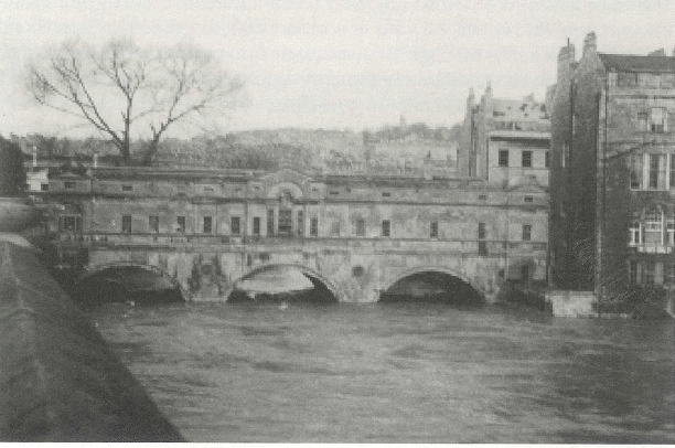
Buchanan, R.A., 1998. Bath History. Millstream Books. Environment Agency and Bath & North East Somerset Council, 2017. Managing flood risk in Bath: Information Note [Online]. ed. Available from: https://www.bathnes.gov.uk/sites/default/files/managing_flood_risk_in_bath_briefing_note_30.01.17_final.pdf Greenhalgh, F., 1974. Bath Flood Protection Scheme. Wessex Water Authority. Smith, R.A.L., 1948. Bath. Third ed. by Ioanna Stamataki and Thomas R. Kjeldsen The river Avon (also known as the Bristol Avon) flows from its source in Gloustershire via Bath and into the sea at Avonmouth near Bristol. The name Avon was derived from a Celtic word meaning “river” and thus shares its name with some other rivers of the United Kingdom, Canada, New Zealand and Australia. In the city centre of Bath, Pulteney Bridge and Pulteney Weir sit majestically on the Avon, providing a beautiful view for residents and visitors alike. 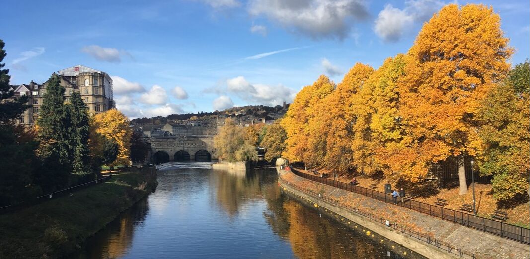 Fig. River Avon, Pulteney Bridge and Pulteney Weir (I. Stamataki, 2016) Pulteney Bridge was designed in 1769 by Robert Adam. The bridge opened in 1770 and is an iconic structure of the city of Bath and is one of only four bridges in the world that has shops on both sides of its full span. Pulteney Weir is situated just downstream of Pulteney Bridge and is Bath’s most recognisable hydraulic structure. The current weir was completed in 1975 and is part of the Bath Flood Protection Scheme implemented following the December 1960 flood to reduce the risk of flooding of the city. It is one of the many engineering obstructions built in the river’s path to control flow; in 1972, it won a Civic Trust Award for “making an outstanding contribution to the appearance of the local scene”. The modern-day Pulteney Weir is a complex shape that can be characterised as a 3-stepped, curved weir. Its three steps create a height difference of 1.5m between each of them with a lowered section in the centre of the weir serving as a fish pass. However, this was not the first weir to be constructed at this site. 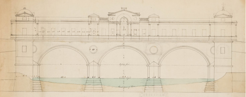 Fig. Robert Adam’s Pulteney Bridge Drawing (Robert, 1770) The Savile Map of Bath, dated 1603, shows the extent of the Elizabethan city and provides the first sighting of a weir in Bath’s city centre, a medieval diagonal weir. The purpose of the weir at the time was to establish a water level difference to power Monk’s Mill. There were two mills on the Avon in Bath then, Monk’s Mill located on the west bank of the river (current location of Parade Gardens with steps leading down to the river) and Bathwick Mill on the east bank (east of Pulteney Weir, where Pulteney Cruisers depart). The weir connected the two mills and a ferry was also in operation (marked on the 1603 map).
Fig. Slideshow of historical maps of the city of Bath in 1572, 1603 and 1818 The first settlement in Bath was founded around 44AD and by 50AD the Romans had built a temple and public baths around the springs for their healing properties. The city was always located close to the river and thus Bath experienced the effects of flooding since the Roman times. Over the centuries, there were many ideas for flood protection schemes and a Flood Relief Committee was formed in 1834 to assess the different schemes. But the construction costs of these schemes were always considered unacceptably high and, as a result, flood victims were compensated financially from different relief funds such as the Mayor’s Relief Fund and the Bath Flood Relief Fund. The 1960 floods resulted in a total damage of £1.4 million which finally catalysed the implementation of the Bath Flood Protection Scheme. The Bath Flood Protection Scheme (1964-1974) comprised 10 different phases and the main implementations included: (i) removal of Old Bridge and replacement with current Churchill Bridge, (ii) dredging and re-alignment of the river, (iii) installation of sheet piling and reinforced concrete walls, (iv) construction of Twerton sluices, (v) deepening of channel around Pulteney Bridge, (vi) removal of old weir and replacement with current Pulteney Weir and (vii) construction of new sluice gate. Pulteney Weir is not simply a weir. It has become one of Bath’s wonders as a beautifully made structure, both fulfilling its function and pleasing in its appearance. If you are interested in learning more about weirs, the practice guide on River Weirs created by the Environment Agency in 2003 is a great start. Fun fact: Hollywood came to Bath in 2012 and Pulteney Weir was featured in the musical drama Les Misérables. Sources
Adam R., 1770. Design for the river front of the bridge, Photo: © Sir John Soane’s Museum, London. http://collections.soane.org/drawings?ci_search_type=ARCI&mi_search_type=adv&sort=7&tn= Drawings&t=THES99351 [Accessed 13 September]. Anonymous, 1823. The Historical and Local New Bath Guide ... Embellished with eight original engravings, and a correct plan of the city. Bath: J. Barratt & Son; H. Gye. BATHNES, 2015. Draft Pulteney Road Character Appraisal Bath Conservation Area. https://www.bathnes.gov.uk/sites/default/files/sitedocuments/Planning-and-Building-Control/Planning-Policy/Placemaking-Plan/pulteney_road_web.pdf [Accessed 19 September]. Britain from Above, 1946. https://www.britainfromabove.org.uk/en/ [Accessed 13 September]. Earle, J., 1864. A Guide to the knowledge of Bath, ancient and modern, London, Bath. Greenhalgh, F., 1974. Bath Flood Protection Scheme. Wessex Water Authority. Manco, J., 1993. Henry Savile's Map of Bath. Somerset Archaeology and Natural History, vol 136, Print. by Ioanna Stamataki
 Photo of Ha'penny Bridge (2019) looking upstream towards Thimble Mill Pumping Station.
Most of these flood levels are extreme and it is important to mention that an aspect that could have affected some of these flood levels was the Old Bridge (current Churchill Bridge) which was a 5-arch bridge that restricted and blocked the flow in many of these events. After the Bath Flood Protection Scheme (1964-1974) was put in place the floods were eliminated in the City of Bath but whether this has to do with the scheme or whether such an extreme event (similar to the historical) has yet to occur is a remaining question. If you are interested in seeing the flood marks of Ha'penny Bridge and hearing more about the historical floods of the city of Bath, join us on Saturday 28th September at 17:30 (Meet at Bath Abbey) for Walking with the Scientists. Walking with Scientists is part of FUTURES, a series of free events taking place across Bristol and Bath to celebrate European Researchers' Night. To book your free ticket, press here. Google maps location of the Ha'penny Bridge flood marks. Sources:
M. Scott, Discovering Widcombe & Lyncombe (2nd ed 1993), 61-65. Fall of a bridge in England. New York Times, 7 June 1877. |