|
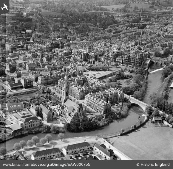
by Ioanna Stamataki and Thomas R. Kjeldsen The river Avon (also known as the Bristol Avon) flows from its source in Gloustershire via Bath and into the sea at Avonmouth near Bristol. The name Avon was derived from a Celtic word meaning “river” and thus shares its name with some other rivers of the United Kingdom, Canada, New Zealand and Australia. In the city centre of Bath, Pulteney Bridge and Pulteney Weir sit majestically on the Avon, providing a beautiful view for residents and visitors alike. 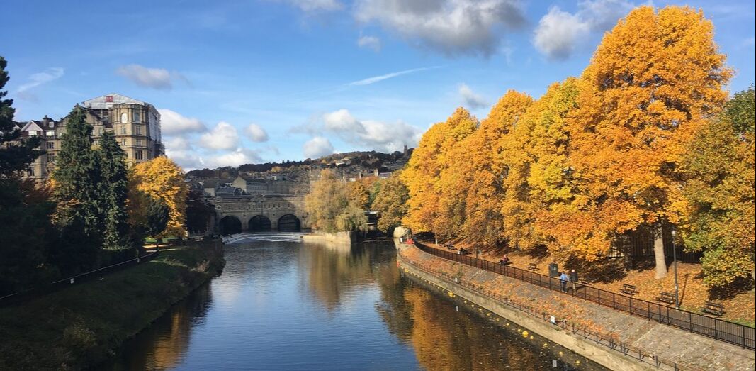 Fig. River Avon, Pulteney Bridge and Pulteney Weir (I. Stamataki, 2016) Pulteney Bridge was designed in 1769 by Robert Adam. The bridge opened in 1770 and is an iconic structure of the city of Bath and is one of only four bridges in the world that has shops on both sides of its full span. Pulteney Weir is situated just downstream of Pulteney Bridge and is Bath’s most recognisable hydraulic structure. The current weir was completed in 1975 and is part of the Bath Flood Protection Scheme implemented following the December 1960 flood to reduce the risk of flooding of the city. It is one of the many engineering obstructions built in the river’s path to control flow; in 1972, it won a Civic Trust Award for “making an outstanding contribution to the appearance of the local scene”. The modern-day Pulteney Weir is a complex shape that can be characterised as a 3-stepped, curved weir. Its three steps create a height difference of 1.5m between each of them with a lowered section in the centre of the weir serving as a fish pass. However, this was not the first weir to be constructed at this site. 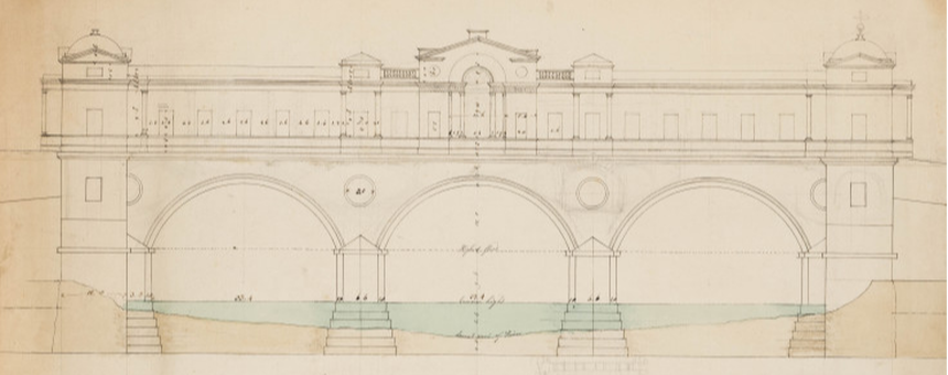 Fig. Robert Adam’s Pulteney Bridge Drawing (Robert, 1770) The Savile Map of Bath, dated 1603, shows the extent of the Elizabethan city and provides the first sighting of a weir in Bath’s city centre, a medieval diagonal weir. The purpose of the weir at the time was to establish a water level difference to power Monk’s Mill. There were two mills on the Avon in Bath then, Monk’s Mill located on the west bank of the river (current location of Parade Gardens with steps leading down to the river) and Bathwick Mill on the east bank (east of Pulteney Weir, where Pulteney Cruisers depart). The weir connected the two mills and a ferry was also in operation (marked on the 1603 map).
Fig. Slideshow of historical maps of the city of Bath in 1572, 1603 and 1818 The first settlement in Bath was founded around 44AD and by 50AD the Romans had built a temple and public baths around the springs for their healing properties. The city was always located close to the river and thus Bath experienced the effects of flooding since the Roman times. Over the centuries, there were many ideas for flood protection schemes and a Flood Relief Committee was formed in 1834 to assess the different schemes. But the construction costs of these schemes were always considered unacceptably high and, as a result, flood victims were compensated financially from different relief funds such as the Mayor’s Relief Fund and the Bath Flood Relief Fund. The 1960 floods resulted in a total damage of £1.4 million which finally catalysed the implementation of the Bath Flood Protection Scheme. The Bath Flood Protection Scheme (1964-1974) comprised 10 different phases and the main implementations included: (i) removal of Old Bridge and replacement with current Churchill Bridge, (ii) dredging and re-alignment of the river, (iii) installation of sheet piling and reinforced concrete walls, (iv) construction of Twerton sluices, (v) deepening of channel around Pulteney Bridge, (vi) removal of old weir and replacement with current Pulteney Weir and (vii) construction of new sluice gate. Pulteney Weir is not simply a weir. It has become one of Bath’s wonders as a beautifully made structure, both fulfilling its function and pleasing in its appearance. If you are interested in learning more about weirs, the practice guide on River Weirs created by the Environment Agency in 2003 is a great start. Fun fact: Hollywood came to Bath in 2012 and Pulteney Weir was featured in the musical drama Les Misérables. Sources
Adam R., 1770. Design for the river front of the bridge, Photo: © Sir John Soane’s Museum, London. http://collections.soane.org/drawings?ci_search_type=ARCI&mi_search_type=adv&sort=7&tn= Drawings&t=THES99351 [Accessed 13 September]. Anonymous, 1823. The Historical and Local New Bath Guide ... Embellished with eight original engravings, and a correct plan of the city. Bath: J. Barratt & Son; H. Gye. BATHNES, 2015. Draft Pulteney Road Character Appraisal Bath Conservation Area. https://www.bathnes.gov.uk/sites/default/files/sitedocuments/Planning-and-Building-Control/Planning-Policy/Placemaking-Plan/pulteney_road_web.pdf [Accessed 19 September]. Britain from Above, 1946. https://www.britainfromabove.org.uk/en/ [Accessed 13 September]. Earle, J., 1864. A Guide to the knowledge of Bath, ancient and modern, London, Bath. Greenhalgh, F., 1974. Bath Flood Protection Scheme. Wessex Water Authority. Manco, J., 1993. Henry Savile's Map of Bath. Somerset Archaeology and Natural History, vol 136, Print.
31 Comments
by Ioanna Stamataki
 Photo of Ha'penny Bridge (2019) looking upstream towards Thimble Mill Pumping Station.
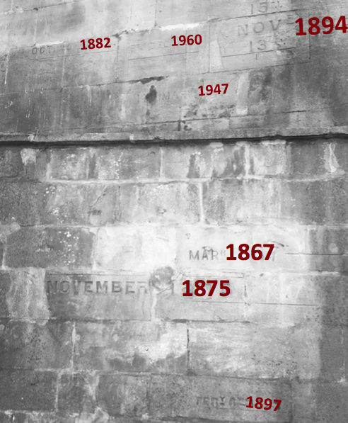
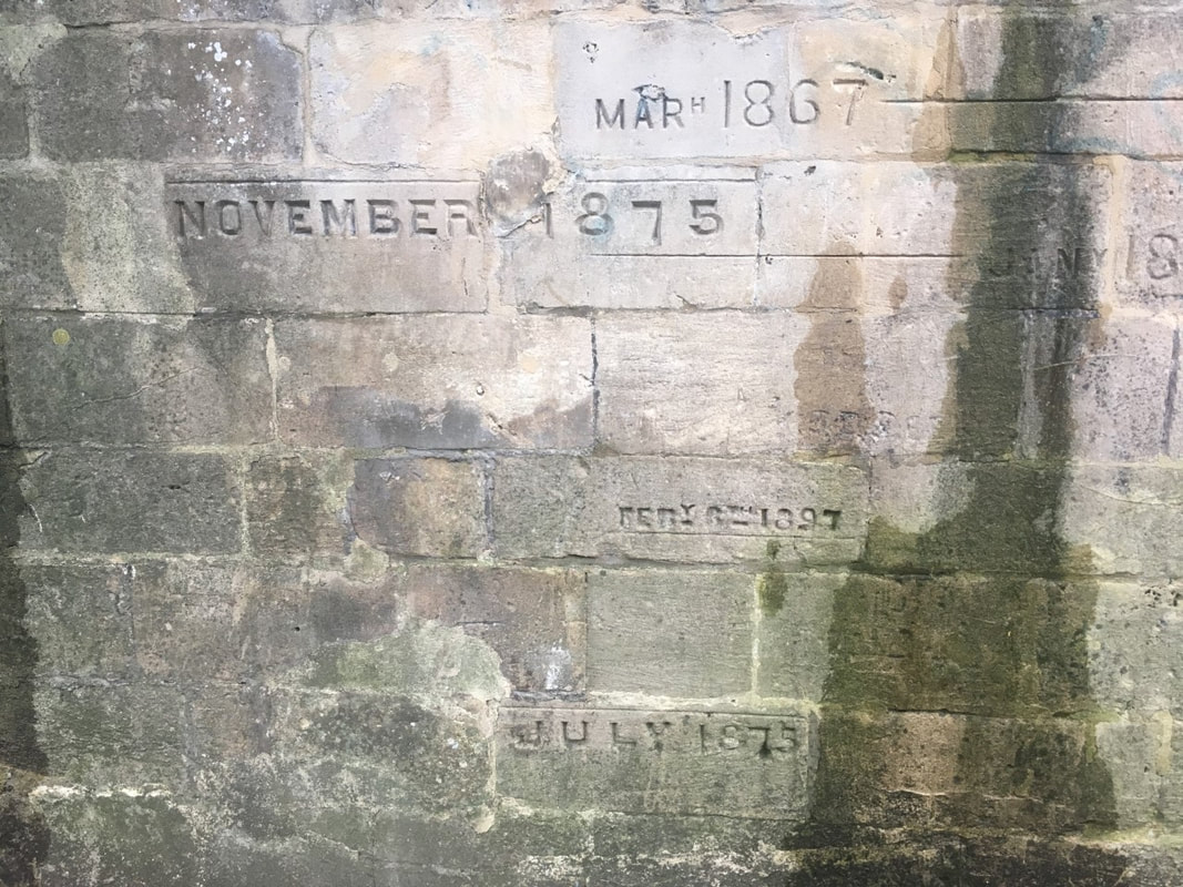
Most of these flood levels are extreme and it is important to mention that an aspect that could have affected some of these flood levels was the Old Bridge (current Churchill Bridge) which was a 5-arch bridge that restricted and blocked the flow in many of these events. After the Bath Flood Protection Scheme (1964-1974) was put in place the floods were eliminated in the City of Bath but whether this has to do with the scheme or whether such an extreme event (similar to the historical) has yet to occur is a remaining question. If you are interested in seeing the flood marks of Ha'penny Bridge and hearing more about the historical floods of the city of Bath, join us on Saturday 28th September at 17:30 (Meet at Bath Abbey) for Walking with the Scientists. Walking with Scientists is part of FUTURES, a series of free events taking place across Bristol and Bath to celebrate European Researchers' Night. To book your free ticket, press here. Google maps location of the Ha'penny Bridge flood marks. Sources:
M. Scott, Discovering Widcombe & Lyncombe (2nd ed 1993), 61-65. Fall of a bridge in England. New York Times, 7 June 1877. |