|
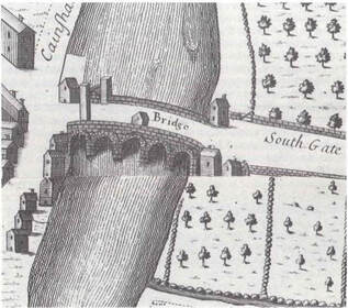
By Ioanna Stamataki and Thomas R. Kjeldsen Bridges are civil engineering structures that often have important historical significance. The City of Bath was built around the banks of the River Avon and the natural springs and the economic prosperity these brought depended upon the construction of important transport routes. Permanent crossing points and bridges therefore played an important role from Roman times. In the last two centuries bridges became an important part of the city, not only for their practicality but also their elegance (Buchanan, 1990). Figure 1. Location of Churchill Bridge in Bath, UK The present-day Churchill Bridge crossing the River Avon in Bath’s city centre (Fig. 2, right) is a single span bridge and represents one of the main routes into the city connecting the centre of Bath to its southern suburbs (see Fig. 1 map). But Churchill Bridge was not always a single span bridge. Initially – where the current Churchill Bridge now stands – a five-arch stone bridge was constructed in 1754 called Old Bridge (Fig. 2, left) only to be replaced in 1965 by the current Churchill Bridge as part of the Bath Flood Protection Scheme. As discussed in previous blog posts, the City of Bath has a long history of flooding going back centuries, and after the important flood of 1960, the Bath Flood Defence Scheme (1964-1974) was initiated and consisted of ten phases aiming to incorporate different improvements to the river hydraulics. Phase I of the scheme was the replacement of Old Bridge with two single span bridges for road (Churchill Bridge) and pedestrian traffic. 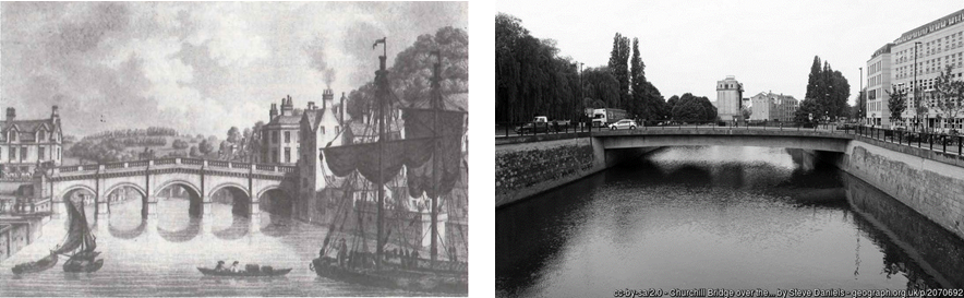 Figure 2. River Avon, Old Bridge (left) and Churchill Bridge (right) However, the story of Churchill Bridge starts much earlier during Roman times with the Roman Bridge located at the same site, an area considered outside the borders of the city until 1590. There is evidence that a more permanent bridge was located there in 1273 (Buchanan, 1990) and it is believed that it was built before 1220 (Somerset HER, 1984), and that there probably was a wooden bridge there even earlier (Buchanan, 1990). At the time it was called St. Lawrence's Bridge (Somerset HER, 1984) and it was a bridge with houses and a chapel dedicated to St Lawrence which survived until 1749 (Buchanan, 1990; Davis, 1857). It is believed that St. Lawrence's Bridge was destroyed during the English Civil War and during 1754, Richard Jones designed Old Bridge which the Bath corporation built on the existing piers of St Lawrence’s Bridge (Ison, 1980).
The view of flooded Saint Laurence's Bridge, and later Old Bridge, with water covering the bridge parapets was a familiar image for the 18th and 19th century Bath residents (Buchanan, 1990). The flooding of Bath has been documented by multiple accounts with flood marks on buildings through-out the city (earliest from 1823) as well as documentary evidence in books, newspapers and technical reports. The floods in Bath were regular and over the years created considerable damage to the city’s property but unusually low numbers of casualties (Buchanan, 1990). The five-arch masonry bridge, Old Bridge, was identified very early as being prone to debris blocking and an obstacle to flow (Greenhalgh, 1974; Buchanan 1990). During the floods it was acting as a bottleneck and was retaining upstream the flood water and occasionally (e.g. 1823 flood) its arches were blocked by lots of timber (Buchanan 1990). Despite different attempts to refurbish the bridge, it remained the most important obstruction to the unrestricted flow of the River Avon on its way through Bath’s City centre and consequently it was removed in 1964-1965 and replaced by the current single-span Churchill Bridge, thereby dramatically changing the river hydraulics. 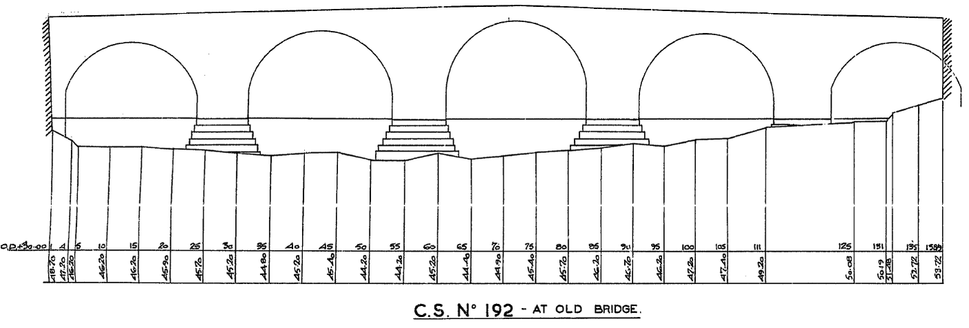 Figure 4. Cross section at Old Bridge taken in 1934 (scanned drawing from the Environment Agency’s Archives, Bridgwater) By creating a simple 1D hydraulic model in the Flood Modeller software, the effect on flood levels of the two different bridges (Old Bridge and Churchill Bridge) was investigated by considering their hydraulic performance during the 1960 flood (Fig. 5). This particular flood was considered a catalyst event for the policy of Bath as due to the city’s development, the economic impact was vast. 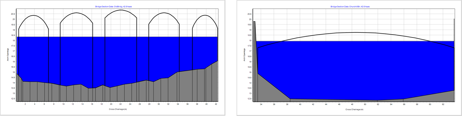 Figure 5. Screenshot of numerical simulation during the 1960 flood event at Old Bridge (left) and Churchill Bridge (right) To investigate the effect of the two bridges, we looked at the time series data of stage (how the water level changed over time) in three locations (Fig. 6):
A way to understand the effect a bridge has in a water stream is to calculate its afflux which is the difference in water level caused on the upstream side of a bridge (the side against the direction of the flow) due to the obstruction. Flood Modeller calculates the afflux on bridges using a method developed by HR Wallingford based experimental data (Brown, 1988). The two graphs on Fig. 6 show the stage time series for Old Bridge (left) and Churchill Bridge (right) during the 1960 flood. What is noticeable is that Old Bridge created a 0.5 metre surge in water level upstream and at the bridge location when compared to the Churchill Bridge because of its geometry restricting flow. 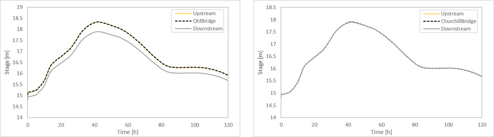 Figure 6. Timeseries of stage during the 1960 flood for Old Bridge (left) and Churchill Bridge (right) Even though the hydraulic behaviour of river systems is complex, especially when hydraulic structures are introduced, Old Bridge proved to have been correctly identified as being prone to debris blocking and an obstacle to the River Avon’s flow. To understand the full effect of the Bath Flood Defence Scheme, requires a complex investigation but as the effect of Old Bridge was very apparent in most historical floods in Bath, understanding the effect of this individual structure was a very important part in our research. Sources
Bird, S. (1986). ‘The Earliest Maps of Bath’ in Bath History, Volume I. Gloucester: pp.128-149. Brown, P. (1988) Afflux at arch bridges. Technical Report. HR Wallingford. Buchanan, R.A. (1990) 'The Bridges of Bath', in Bath History, Volume III. Gloucester: pp.1-21. Davenport, P., 2002. Medieval Bath Uncovered. Tempus. Davis, C.E. (1857) On the Churches of Bath. Journal of the British Archaeological Association, 13.2, 135 Environment Record [Online]. South West Heritage Trust. Available from: https://www.somersetheritage.org.uk/record/61616 [Accessed 25 May]. Greenhalgh, F. (1974) Bath Flood Protection Scheme. Wessex Water Authority Ison, W. The Georgian Buildings of Bath. (1980), 46-48. Somerset Historic Environment Record HER, 1984. St. Lawrence's Bridge, E of Churchill Bridge, Bath: Bath & NE Somerset Historic Wood, John, 1765 (2edn), A Description of Bath (London) p. 325, 326
1 Comment
11/11/2023 19:42:58
HI! I wonder if I might pick your brains. My grandfather was a civil engineer and in 1934 demolishes two bridges in Bath. [At least] one of them was decorated with cast-iron Welsh dragons. Does this ring any bells? Leave a Reply. |