|
By Ioanna Stamataki and Thomas R. Kjeldsen Twerton, also known as Twiverton on Avon, is a suburb of the city of Bath, located to the west of the city, and home to Twerton Weirs built as part of the Bath Flood Protection Scheme. As discussed in previous blog posts, the City of Bath has a long history of flooding going back centuries, and after the important flood of 1960, the Bath Flood Defence Scheme (1964-1974) was initiated and consisted of ten phases aiming to incorporate different improvements to the river hydraulics. Phases IV & V of the scheme were the removal of the two weirs at Twerton and replacement by a twin automatic sluice barrage. Twerton is considered a Saxon settlement on the River Avon but there is evidence that the village existed since the Roman times (THE BATH Magazine, 2020). It was considered outside the borders of the city until 1911 but it was known for its mills milling corn and later cloth. This is translated into its name “Twerton” which is derived from an Anglo-Saxon word meaning “Two Weirs” and illustrating the suburb’s riverside location (THE BATH Magazine, 2020). 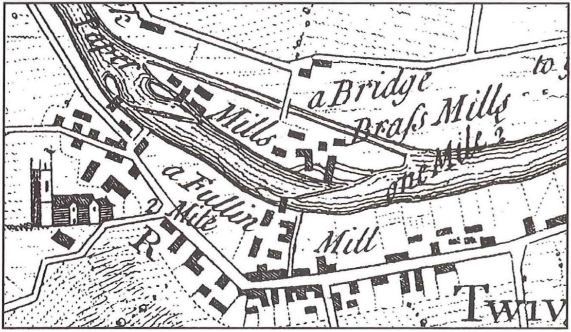 Figure 1. Map of Twerton mill sites in the eighteenth century (Von Behr, 1996). At the beginning of the Industrial Revolution, the West of England was known for its wool textile manufacturing. Twerton had five mills located around the two weirs that were being leased (Figure 1). Twerton’s manufacturing was therefore indistinguishably connected with the River Avon and the weirs. The first mention of a weir appears as early as 945 AD (Von Behr, 1996). Joan Day (1987) writes “Two adjacent weirs (Figures 1,2) both served ancient fulling-mill sites on either bank of the Avon which here divides Weston and Twerton. Other diverse industries later occupied the sites, but the complex survived into this century mainly as large cloth-mill premises”. In the middle of the sixteenth century the Bath cloth industry collapsed, and by the seventeenth century the downstream mills were reverted to grist milling¹ (Von Behr, 1996). 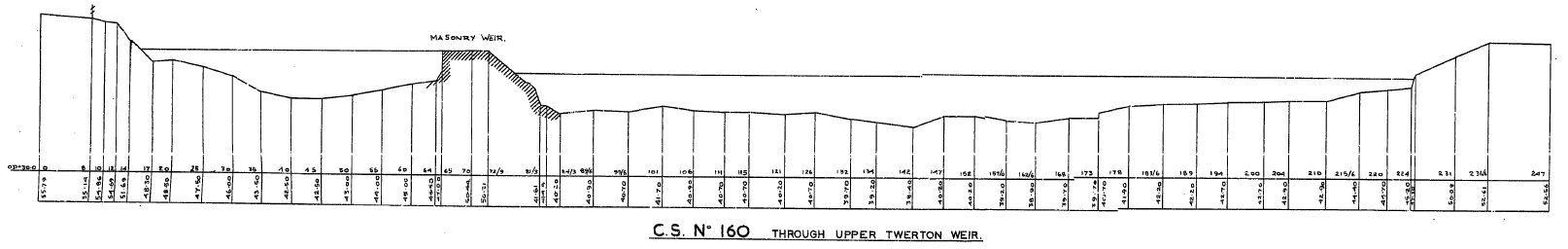 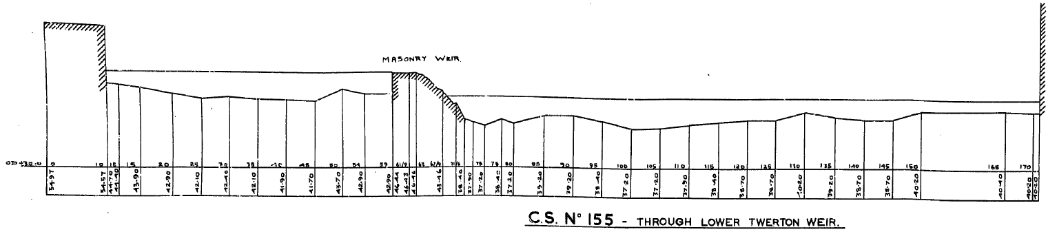 Figure 2. Cross sections of upstream (top) and downstream (bottom) Twerton Weirs In 1727, the Avon Navigation was completed connecting Bath to Bristol for navigation and during this time the Weston cut was created; a man-made channel on the north bank of River Avon created to allow boats to go through Weston lock. Between the river and Weston cut, an island was created, Dutch Island, which took its name from one of the brass mill owners (Allsop, 1989; Von Behr, 1996). The Weston cut left the existing Weston mills somewhat isolated on Dutch Island with a single footbridge access erected in 1728 (Day, 1987). 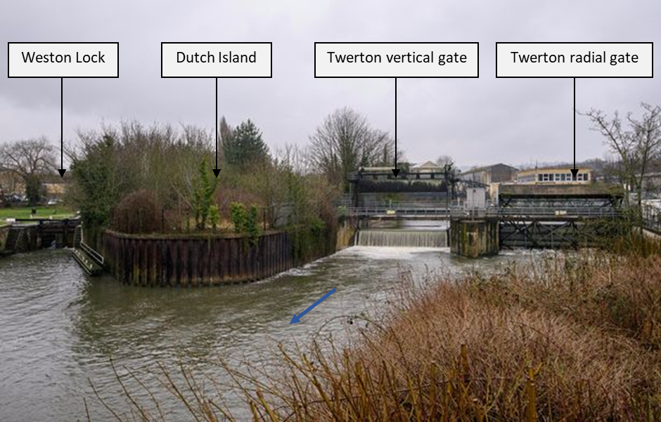 Figure 3. Photo of twin gate system at Twerton looking upstream. The photo shows the Weston Lock, Dutch Island, Twerton vertical gate and the Twerton radial gate. The blue arrow represents the direction of the flow (Somerset Live, 2018). Figure 4. Map showing the location of the twin gate system at Twerton Phases IV & V of the Bath Flood Defence Scheme were completed in June 1968 (Greenhalgh, 1974) and the two weirs (Figure 2) that stood at Twerton were replaced by a twin gate system (Figure 3 and Figure 4), a vertical and a radial gate spanning the length of the river (BATHNES, 2016a). Their purpose is to maintain the water level in the city centre within a viable range to: (i) facilitate navigation, and (ii) protect the historical World Heritage building foundations. Operation of the sluice gate is automated, and it opens/closes as required to maintain the required water level (BATHNES, 2016a). The usual water level range within the Twerton Gates Monitoring Station operates the gates is between 15.42 and 15.54 mAOD (River Levels, 2020). In October 2019, the Twerton radial gate got stuck open due to a fault causing the water level to drop by 0.8 m overnight and a further 0.1 m in the morning. The gate was fixed into its closed position and the levels were controlled by the remaining Twerton gate (Bath Echo, 2019). Figure 5 below shows the data available from the River Levels database showing the minimum daily water level recorded between June 2019 and June 2020. The sudden drop in the data represents the October incident and shows the extraordinary water level drop in October. 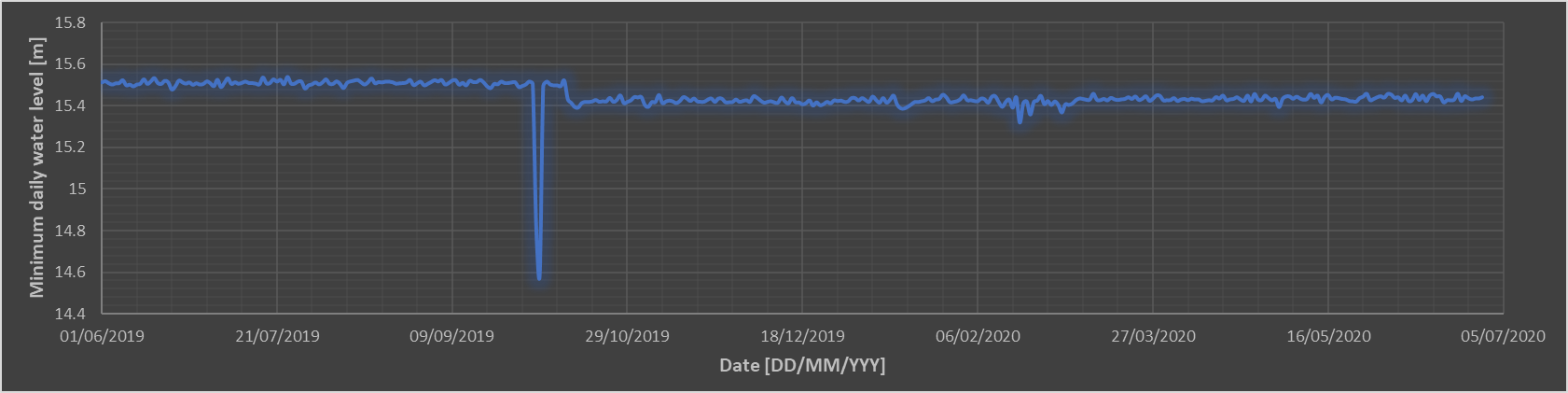 Figure 5. Timeseries of minimum daily water level between June 2019 and June 2020 (Data from River Levels, 2020 The Bath & North East Somerset Council in their 2016 “Bath River Options Appraisal Report” have been discussing the possibility to replace the Twerton gates. It is recognised that these structures play an indispensable role in the flood risk protection of the city of Bath and are looking into many different options taking into account efficiency, economic benefits, environmental enhancements and climate change. The short-listed options that were decided in this report were: (i) do minimum, (ii) replace both gates and (iii) replace both gates with a variable height weir (BATHNES, 2016b). ¹ A mill, especially one equipped with large grinding stones for grinding grain (Collins English dictionary, 1994). Sources
Allsop, N., 1989. The Kennet & Avon Canal. 2nd ed. Millstream Books. Bath Echo, 2019. Twerton sluice gate fault sees River Avon water levels drop across Bath [Online]. Available from: https://www.bathecho.co.uk/news/community/twerton-sluice-gate-fault-sees-river-avon-water-levels-drop-across-bath-86584/ [Accessed 25 June]. BATHNES, 2016a. Flood risk in Bath. Available from: https://www.bathnes.gov.uk/sites/default/files/siteimages/Environment/flood_risk_in_bath_feb_2016.pdf BATHNES, 2016b. Bath River Avon Options Appraisal Phase 1b and 2. Available from: https://www.bathnes.gov.uk/sites/default/files/river_avon_options_appraisal_report_phase_1b2_final_v3_20.09.16.pdf Collins English dictionary. (1994). Glasgow: HarperCollins Publishers. Day, J., 1987. A guide to the industrial heritage of Avon and its borders. Association for Industrial Archaeology. River Levels, 2020. Twerton Gate Monitoring Station [Online]. Available from: https://riverlevels.uk/somerset-twerton-gate#.XwbyhSgzY2xTwerton%20Gate%20Monitoring%20Station [Accessed 25 June]. Somerset Live, 2018. Hundreds of Twerton homes to benefit from multi-million-pound flood defence investment [Online]. Available from: https://www.somersetlive.co.uk/news/hundreds-twerton-homes-benefit-multi-1392912 [Accessed 25 June]. THE BATH Magazine. 2020. History: Indispensable Twerton. [ONLINE] Available at: https://thebathmagazine.co.uk/history-indispensable-twerton/ [Accessed 30 June 2020]. Von Behr, N., 1996. The cloth industry of Twerton from the 1780s to the 1820s Bath History Volume VI. Available at: http://historyofbath.org/images/BathHistory/Vol%2006%20-%2005.%20von%20Behr%20-%20The%20Cloth%20Industry%20of%20Twerton%20from%20the%201780s%20to%20the%201820s.pdf
0 Comments
|
